More Lidar for Montana
HELENA, MT -- The Montana State Library is pleased to announce the Lidar Program submitted a successful application to the U.S. Geological Survey 3D Elevation Program (3DEP). USGS 3DEP will allocate $3.4 million to collect additional elevation data of Montana.
“It is exciting to see more lidar data coming to Montana. The State Library is on a quest to achieve statewide, high-resolution elevation data and this latest phase brings the state ever closer to that goal. We have identified dozens and dozens of uses of lidar data by state, federal, tribal, and local partners. Lidar is a smart investment in Montana for natural resources, water resources, infrastructure, transportation planning, and more,” said Troy Blandford, Water Information and Elevation Theme Lead at the Montana State Library.
These funds will be combined with $1.1 million in partnership funds from Natural Resources Conservation Service (NRCS), Bureau of Land Management (BLM), United States Forest Service (USFS), and United States Fish and Wildlife Service (USFWS).
The $4.5 million in funding will allow for further acquisition of elevation data using Lidar technology. Lidar uses light pulses from a laser device mounted to an aircraft to generate high-quality 3-D information about the bare-earth, its elevation, and the height of surface characteristics, such as vegetation and buildings.
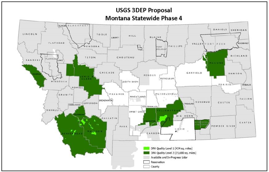
In 2022, a specialized aircraft will fly 22,114 square miles of Montana to collect expansive county-wide and regional elevation data across the western, southwest, and south-central regions of the state. Eight counties and the Northern Cheyenne reservation will be collected.
This elevation data will be used by state, federal, local, tribal, and private organizations. Lidar-derived products are needed for soils mapping, cropland planning, geologic mapping, forest inventory and monitoring, vegetation characterization, flood-risk mapping, and conservation planning. Montana’s existing Lidar data has been used to plan state park facilities, improve highways, delineate building footprints, plan timber sales, and do archaeological surveys.
The Montana State Library serves the information needs of all branches of state government, its agencies, local counterparts, and individuals seeking information not found in their local libraries. GIS land information is a core informational need of Montana, and the State Library serves these needs with our Geographic Information Program.
As part of this program, the State Library collects, maintains and disseminates lidar data products in a central repository. To learn more about Lidar for Montana please visit: Lidar Inventory | MT State Library or contact Troy Blandford at (406) 444-7930, TBlandford@mt.gov.